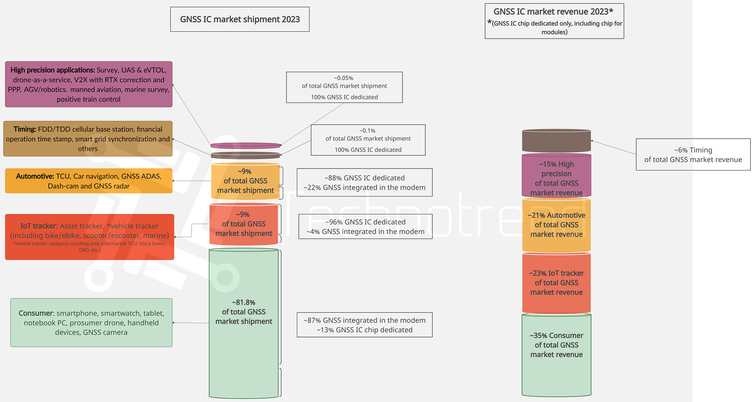
Above the representation of GNSS total shipment and related total revenue by main verticals
GNSS general market introduction
The GNSS device market is witnessing dynamic trends across various sectors, reshaping the landscape of global positioning technologies. In consumer electronics, smartphones and smartwatches are embracing GNSS multi-frequency systems, indicating a broader push for enhanced location accuracy. While tablets and laptops show limited GNSS adoption, dedicated bike computers present a counter-trend, revealing a specialized market preference. In the prosumer drone market, growth faces a dual effect of saturation and regulatory frameworks, steering adoption at a measured pace. In consumer market applications other than smartwatches the presence of GNSS into modem is dominant (~87%). Regarding the total revenue, GNSS consumer industry represent only 35% of the total GNSS IC market.
The GNSS tracker market experiences unprecedented demand worldwide, driven by regulatory mandates, safety imperatives, and operational efficiencies. From fleet safety in the Americas and Europe to economic benefits in emerging markets like Mexico and Vietnam, GNSS trackers play a vital role in reshaping commercial transportation globally. In the GNSS tracker market the majority part is represented by GNSS IC dedicated (both chip-on-board or inside module) into the devices (~96%).
In the automotive sector, TCUs with GNSS are becoming integral for location-based services, fleet management, emergency services, and stolen vehicle recovery. While the EU mandates in-vehicle eCall systems, countries like Japan and India enforce similar regulations, reflecting a global trend towards enhanced safety features. The car navigation market, driven by real-time traffic updates and smartphone integration, anticipates substantial growth, reaching a significant share of total vehicle sales by 2030.
In the context of dash cams, a trend towards edge-based AI, 4G IoT connectivity, and GNSS integration is evident. This evolution not only enhances accident evidence but also contributes to mileage logging and route tracking, transforming these devices into valuable tools for logistics management and accountability.
For automotive the shipments with GNSS IC dedicated is estimated to ~88% with a 21% of total GNSS revenue share. Similarly GNSS trackers have 23% of the revenue share.
Centimeter-level GNSS precision is becoming imperative across industries, from enterprise drones and eVTOLs revolutionizing shipping to AGV robotics in industrial settings. In the automotive sector, high-precision GNSS plays a pivotal role in the evolution of ADAS, contributing to the safety and reliability of autonomous vehicles. Collaborative initiatives globally, such as EUSPA's advancements with Galileo, demonstrate concerted efforts to refine GNSS technologies.
The GNSS timing sector experiences continuous advancements, translating into more accurate timing signals for critical applications like PTP, power grids, financial transactions, and cellular networks. With cellular network adoption dominating GNSS timing modules, the market is expanding into emerging applications like smart factories AGV/process synchronization.
GNSS centimeter high precision and GNSS timing and synchronization have mostly been adopted by module solutions and despite limited shipments the revenue generated is very high, with a share revenue of ~15% for GNSS high precision and ~6% for GNSS timing.
In a nutshell, the GNSS device market is undergoing a transformative phase, with diverse applications driving innovation and reshaping industries on a global scale.
GNSS Consumer overview
The smartphone market is gradually adopting GNSS multi-frequency systems. This technology breakthrough not only enables precise sub-meter navigation but also extends to smartwatches, reflecting a broader industry push towards enhanced location accuracy in wearable devices.
Tablets with GNSS remain mainly iPad and rugged tablets adopted for surveys. Regarding laptop adoption of GNSS, it is limited to a few models for business and embedded into modem.
Prosumer drone market growth is at a slower pace. This is attributed to a dual effect: a saturation of consumer adopters and the emergence of stricter regulatory frameworks. These factors together shape the trajectory of drone adoption, steering it towards a more measured ascent.
While GNSS handheld devices experience a decline in demand due to the superior accuracy offered by smartphones, an interesting counter-trend emerges in the realm of dedicated bike computers. Despite shipment limitations, there is a notable rise in demand, indicating a specialized market preference for dedicated navigation solutions in the cycling community.
GNSS tracker overview
The GNSS (Global Navigation Satellite System) tracker market is witnessing an unprecedented surge in demand across diverse global regions, catalyzed by regulatory mandates, safety imperatives, and operational efficiencies. From North and South America to Australia, Europe, emerging markets like Mexico, Vietnam, the Middle East, and India, the trajectory of GNSS technology adoption is reshaping the landscape of commercial transportation.
In the Americas and Europe, a rapid increase in fleet safety and accountability drives the adoption of OEM GPS trackers, propelled by insurance companies advocating for verifiable vehicle usage data to manage compliance and mitigate risks.
Australia, with its expansive and remote terrain, experiences a broader usage of GNSS tracker utilization, particularly in logistics and transportation sectors, facilitating asset monitoring.
Emerging markets such as Mexico and Vietnam embrace GNSS technology for its economic benefits, attracting businesses keen on cost savings in fuel and labor.
The Middle East, witnesses a heightened demand for high-quality OEM GPS trackers due to stringent regulatory requirements for precise vehicle tracking, ensuring safety and security.
India started to mandate GNSS trackers, for all commercial vehicles, emphasizing safety for passengers, curbing tax evasion, and ensuring permit compliance. Moreover, vehicles transporting hazardous goods require GNSS trackers, adhering to national standards. These trackers, complying with AIS 140 standards, monitor vehicle performance, enhance cargo and passenger safety, and optimize travel routes. Recent disruptions in vital trade routes like the Suez Canal highlight the heightened demand for GNSS trackers in logistics operations, bolstering efficiency for both shipments and vehicles.
Beyond compliance and safety, GNSS trackers prevent theft during transit, optimize global logistics trajectories, and ensure real-time monitoring. They provide logistics companies with crucial visibility into shipment status, creating secure and reliable supply chains. In the face of challenges along traditional shipping routes, GNSS trackers empower operators to adapt, offering alternative routes and maintaining the reliability of global logistics operations.
In Japan, The Ministry of Land, Infrastructure, Transport, and Tourism aims to introduce "soft meters," leveraging GPS for taxi fare computation, aiming to enhance driver efficiency and integrate "dynamic pricing" through AI analysis. These soft meters, unlike conventional ones relying on tire rotation, calculate fares based on GPS data, automating daily driver reports to ease operational burdens. To standardize performance, Japanese Industrial Standards (JIS) are set to be established in 2023. Despite variations in tested prototypes, with up to a 14.48% distance error, the ministry seeks to define error margins and map update frequency for widespread industry adoption.
Electronic Toll Collection (ETC) devices, featuring GNSS capabilities, are gaining traction globally, particularly in motorway e-toll payments. In the United States, states have embraced ETC with varied adoption timelines. China is actively modernizing toll collection through ETC and GNSS integration, with several projects. Japan seamlessly incorporates GPS into toll infrastructure. South Korea enhances ETC with GPS, while India enhacing its NETC (National Electronic Toll Collection) for toll efficiency. Brazil, Malaysia, and Turkey successfully optimize toll collection and improve transportation management through ETC systems with GPS. The adoption of GNSS in ETC continues, reflecting a growing demand for these devices worldwide.
Regarding asset tracking, in the U.S. market from 2026, The FDA's Food Traceability Rule, rooted in FSMA's Section 204(d) will start to be effective, accelerates identification and removal of possibly contaminated food, reducing foodborne illnesses. Entities handling listed foods must maintain precise records of Key Data Elements (KDEs) for specific Critical Tracking Events (CTEs) and share this data with the FDA within 24 hours. GPS tracking integration in CTEs along supply chain routes increase risk identification speed and accuracy. The bill applies to domestic and foreign firms involved in U.S. food production. This implementation is expected to boost the demand for GNSS asset trackers of more than 20% reaching the total GNSS asset tracker shipments to reach around 100 M units yearly. Other than GNSS other sensors alongside will be adopted for traceability technology like, WiFi, UWB, Bluetooth and NFC.
During the COVID-19 restrictions of 2020 and 2021, shared mobility adoption, including bike and scooter sharing, experienced an increase of demand globally. However in 2023, all the restrictions were removed, so the demand has curbed. Notably, China, the largest market for shared bike mobility, responded by implementing regulations limiting the number of bikes in each municipality. This strategic move aims to prevent the excessive oversupply witnessed in 2017, promoting sustainable growth year over year. Not only in China, but in Japan, and in Western Countries the regulatory measures reflect a concerted effort to balance demand and supply, ensuring a more organic and economically viable expansion of shared mobility services in the post-pandemic landscape.
In essence, GNSS trackers have become indispensable tools, ensuring compliance, safety, and operational efficiency in commercial transportation on a global scale, especially in scenarios of prolonged shipment lead times or unforeseen disruptions.
GNSS Automotive overview
Car TCU/eCall
The integration of Global Navigation Satellite System (GNSS) in Car Telematics Control Units (TCUs) is primarily driven by the demand for advanced navigation, location-based services, and improved overall vehicle connectivity. GNSS technology, which includes systems like GPS, enhances the capabilities of TCUs in the following ways:
1. Location-Based Services: TCUs with GNSS support location-based services, such as real-time traffic updates, points of interest, and geofencing, enhancing user convenience and experience.
2. Fleet Management: In commercial vehicles, GNSS-enabled TCUs play a vital role in fleet management, allowing for accurate tracking, route planning, and monitoring of vehicle movements, improving operational efficiency.
3. Emergency Services: GNSS helps in accurately determining the location of a vehicle during emergencies, enabling prompt response from emergency services (eCall).
4. Stolen Vehicle Recovery: GNSS enhances the ability to track and recover stolen vehicles, improving vehicle security.
The adoption of Car TCUs with GNSS is a global trend, several Countries in particular where there is a stronger car TCU presence, such as:
1. United States: The U.S. has been at the forefront of adopting advanced automotive technologies, including TCUs with GNSS for navigation and connected services.
2. EU: Germany among other EU Countries has witnessed widespread adoption of TCUs with GNSS, especially in luxury and high-end vehicles. Outside the EU, UK has been adopting TCUs with GNSS for improved navigation and connected services.
3. China: With a rapidly growing automotive market, China has embraced connected car technologies, contributing to the adoption of TCUs with GNSS.
4. Japan: has seen significant adoption of TCUs with GNSS for navigation and safety features.
5. South Korea: The automotive industry in South Korea has been incorporating advanced telematics technologies, including GNSS-enabled TCUs.
The EU eCall policies specify the mandatory installation of 112-based in-vehicle eCall systems relying on GNSS in all new vehicles from March 31, 2018.
In 2018, Japan introduced UNECE-R144, mandating accident emergency call systems (AECS) in new pick-up, truck, van (up to 3.5 tons), and 8+ seat vehicles. A 1.5-year transition for new models and a 3-year period for in-production vehicles were set. AECS aims to reduce rescue time by 4 minutes based on official statistics. Additionally, Japan's advanced D-Cal system is anticipated to save an average of 17 minutes in rescue services.
India has also stipulated that from April 1, 2019, all passenger vehicles such as taxis and buses must be equipped with the device AIS 140 Tracker.
Besides the EU, also Russia, the United Arab Emirates and Saudi Arabia have also launched their eCall bills. By January 2024, other Countries have started to adopt eCall infrastructures, such as: Malaysia, Singapore, Macau, Taiwan, China, Hong Kong, Thailand and South Korea, spreading the adoption of positioning service in-car TCU. In North America (U.S and Canada) a similar eCall system is already adopted: the E-911.
China’s eCall market is awaiting the accompaniment of policies.
Car navigation
Modern features such as voice recognition, predictive route planning, and other innovations are becoming integral to keeping pace with market trends.
Real-time traffic updates have become a standard in navigation systems, aiding drivers in making informed decisions. In addition to avoiding traffic, modern car navigation systems could offer dynamic maps displaying nearby points of interest like gas stations and restaurants and regarding BEVs or PHEV car navigation systems could address more precisely the charging points suggested and the estimated time required. Smartphone integration is a prominent trend, with Apple CarPlay and Android Auto widely adopted, enabling drivers to control navigation through their mobile devices, making the choice for an aftermarket car navi only for a retrofit car choice, or for specific regions.
About the new challenges Car OEMs are facing secure connectivity systems and exploring flexible payment options to make advanced navigation technology more accessible.
Aftermarket car navigation systems could compete with in-vehicle integrated systems only enhancing functionalities, like including PoI, providing extended update mapping services and real time traffic monitor. An emerging trend is related to the motorcycle GPS navigation systems, that is incrementing the demand. These devices are preferred compared to smartphones thanks to weatherproof electronics that mean more durable products.
GNSS in L2 ADAS
In the dynamic of Advanced Driver Assistance Systems (ADAS), Subaru Eyesight X and Ford BlueCruise stand out as prominent offerings, each bringing Level 2 capabilities to enhance driving safety and convenience.
Subaru EyeSight X represents a leap forward in Advanced Driver Assistance Systems (ADAS) functionality by seamlessly combining location information sourced from GPS and the Quasi-Zenith Satellite (QZSS). This innovative integration is further enhanced by three-dimensional high-precision map data.
This integration includes lane-by-lane road information on designated automobile-only roads meeting specific conditions. The result is a sophisticated ADAS that not only reacts to immediate surroundings but also proactively navigates through complex road scenarios with a heightened level of accuracy.
In essence, Subaru EyeSight X showcases the future of ADAS, where GNSS plays a pivotal role in elevating navigation capabilities. By intricately combining satellite location data with detailed map information, EyeSight X ensures that drivers experience a new dimension of precision and reliability in their driving assistance systems.
Ford's contribution to the Level 2 ADAS landscape is BlueCruise, a system equipped with hands-free driving capabilities. Boasting features like adaptive cruise control with lane centering, BlueCruise takes a distinctive approach by utilizing a combination of cameras and radar sensors. In contrast to some counterparts, it does not primarily depend on GNSS for its operations, emphasizing a sensor fusion approach for comprehensive road awareness.
SAE Level 2's evolution marks a pivotal moment in automotive technology, with adaptive cruise control and lane-keeping assistance becoming commonplace. The shift to fusion positioning, integrating Global Navigation Satellite System (GNSS) data with other sensors, proves a pragmatic solution. This fusion elevates precision and reliability, amplifying overall Level 2 ADAS effectiveness.
In the maturation of ADAS L2 technology, car OEMs are strategically embracing fusion positioning. This move extends advanced driver assistance benefits to lower-tier segments, promising enhanced security and safety features for a wider array of vehicles.
GNSS dash cam overview
A new trend in the dash cam market is emerging, leveraging edge-based AI and 4G IoT connectivity, offering a comprehensive solution for anticipating, preventing, and defending against on-road and parking incidents.
Modern dash cameras, particularly Mirror Dash Cams, offer substantial improvements over traditional models by enabling continuous recording during accidents, serving as crucial evidence. Upcoming trends include integration with the Internet of Things (IoT), enhancing error detection and contributing to overall driver safety. Built-in Wi-Fi functionality facilitates user connectivity with the dash camera.
Dash Cam manufacturers now collaborate with car OEMs to provide personalized solutions, incorporating features like Wide Dynamic Range (WDR) technology for enhanced image quality. Universal touch screen technology ensures seamless operation, while superior night vision capabilities, exemplified by multiple lenses and aperture technology, improve visibility in low-light conditions.
Another important factor related to cloud connectivity has emerged as a key trend, enabling remote access and storage of dash cam footage. Real-time alerts and updates further contribute to the appeal of these connected devices. Dual-channel systems are witnessing increased demand, capturing both front and rear views to provide comprehensive coverage and address concerns from multiple angles.
Integration with telematics systems is another notable trend, fostering a holistic approach to vehicle monitoring by combining driving data with video footage. Enhanced parking mode features, regulatory compliance measures, user-friendly interfaces, energy-efficient designs, and a focus on durability collectively showcase the market's response to evolving consumer preferences.
Furthermore, these advanced dash cams feature a waterproof body structure, ensuring functionality even in adverse weather conditions. Together, these innovations mark a significant step forward in dash cam technology, promising enhanced safety and user experience on the road.
The increasing adoption of GNSS sensors within dash cams is anticipated to solidify their market share. Beyond serving as crucial accident evidence, these devices with integrated GPS bring additional benefits such as mileage logging and route tracking. The integration of GNSS technology not only enhances the functionality of dash cams but also aims to meet the diverse needs of businesses, providing a valuable tool for efficient logistics management and accountability. As a result, the combination of dash cams and GNSS sensors is poised to play a pivotal role in not only capturing incidents on the road but also in optimizing operational processes and ensuring transparency in various professional sectors.
GNSS Centimeter high precision overview
In the era of rapid technological advancement, the integration of high-precision Global Navigation Satellite System (GNSS) receivers has become imperative across various industries. Enterprise drones, with applications ranging from aerial surveys to infrastructure inspection, demand centimeter-level accuracy for optimal performance. Delivery drones, reshaping logistics, rely on precise navigation to ensure efficient and secure parcel transportation.
Smart agricultural drones, equipped with centimeter-accurate GNSS, enhance farming practices by enabling precision agriculture. Autonomous Ground Vehicles (AGVs) in industrial settings leverage this technology for exact positioning, streamlining material handling and logistics operations. Moreover autonomous driving of Level 3 and beyond in Advanced Driver Assistance Systems (ADAS) for automobiles, centimeter high precision GNSS plays a pivotal role in enhancing the safety and reliability of autonomous vehicles.
Enterprise Drones and eVTOLs:
The future of shipping and aerial services is bound to be revolutionized by high-precision GNSS applications. From enterprise drones for inspections to delivery drones, these innovations are set to reshape logistics, with current limitations in urban areas awaiting regulatory clarity. DJI's Agra series in agriculture and the use of GNSS in electricity grid inspections exemplify the potential.
Regarding eVTOL taxi services, there are many investments in several important City Hubs such as: Singapore, Milan, New York, Seoul, among others.
Japanese conglomerates Sumitomo and Kanematsu are set to elevate Singapore's electric Vertical Takeoff and Landing (eVTOL) landscape. This collaboration marks a significant step for Japan's internationalized eVTOL industry.
Milan planning for Skyports/vertiports and air taxis at 2026 winter Olympics.
New York city reveals plans to build air taxi infrastructure. Volocopter, Joby flights and Archer Aviation are testing their services to cover the service once available.
South Korea will launch the first urban air mobility services in Seoul by 2025.
AGV Robotics:
Automated Guided Vehicles (AGVs) and robotics are enhancing efficiency and safety in industrial settings, thanks to centimeter-level GNSS precision. In the absence of GNSS, navigation systems employ a combination of inertial data, Light Detection and Ranging (LiDAR), Simultaneous Localisation and Mapping (SLAM), and Ultra-Wideband (UWB) for robust positioning solutions. A great example is the demand for precision extends from semi-automatic track laying in rail projects, as seen in Malaysia's East Coast Rail Link, where the installation with semi-automatic methods, achieving 1.5 kilometers per day. This system utilizes advanced rail laying gear from China Communications Construction Company, it adopts China's complex track laying standard and high-precision BeiDou satellite navigation ensures precise positioning, allowing self-location with GPS or BeiDou for 10mm track laying accuracy.
Advanced ADAS:
In the automotive sector, the demand for precision extends to the evolution of Advanced Driver Assistance Systems (ADAS) and autonomous driving. Honda's SENSING systems, NIO Aquila's Super Sensing, and Mercedes-Benz's Drive Pilot SAE L3 showcase how GNSS technology, coupled with advanced sensors, is reshaping vehicular safety and automation. GM supercruise adopts Qualcomm+Trimble RTX, and electric vehicle manufacturers such as Li Auto and Xpeng Motors, are adopting U-Blox ZED-F9K GNSS high-precision module for their vehicles. These implementations ensure centimeter-level accuracy, even in challenging urban environments, fostering the growth of autonomous driving features.
For L4 , several Robotaxi services are already provided in China (AutoX, DiDi Chuxing, Baidu, Hesai) and U.S. (Waymo, Cruise, Pony.ai).
Collaborative Initiatives and Global Navigation Advances:
International collaborations, such as the European Agency for the Space Program's (EUSPA) advancements with Galileo's high accuracy service (HAS), demonstrate the global effort to refine GNSS technologies. Testing in diverse scenarios, including drone navigation and maritime applications, aims to tailor GNSS solutions to industry-specific demands.
GNSS Timing overview
Advancements in GNSS timing accuracy refer to continuous enhancements in the precision of timing signals provided by Global Navigation Satellite Systems. Over the years, improvements in GNSS-based positioning have translated into more accurate timing information. For instance, the newer GNSS receiver platforms have played a significant role by introducing scalable and affordable high precision positioning down to the decimeter level. This innovation, utilizing a new generation of multi-constellation, multi-band, high accuracy GNSS receivers, has enabled a notable improvement in timing accuracy too, offering industries access to five nanoseconds of timing accuracy for absolute time, and even less for relative time. These improvements provide cost-effective solutions that reshape how various industries synchronize their operations. The benefits extend to Precision Time Protocol (PTP), power grids, financial stamp transactions, and cellular networks are among the sectors embracing this technology. GNSS's ability to enhance accuracy and reliability makes it a versatile choice for a range of critical applications.
In terms of total shipments, GNSS timing modules market is dominated by cellular network adoption (more than 85%). Among all the other applications, Smart factories AGV/process synchronization is emerging as a new application for GNSS GNSS-enabled wireless timing stands out as a low-cost solution, facilitating the seamless operation of fast production lines, coordinating the activities such as machine movements, assembly line processes, and robotic actions, optimizing the overall efficiency of production. Its ease of deployment and traceability to UTC make it an attractive option for industries aiming for precision without complexity.